GPS vs GPRS: Why is the tracker online but without location information?
Understanding the duality between network connectivity and satellite reception is fundamental to diagnosing the status of a monitored fleet. Understand the science behind the "blind tracker" paradox.
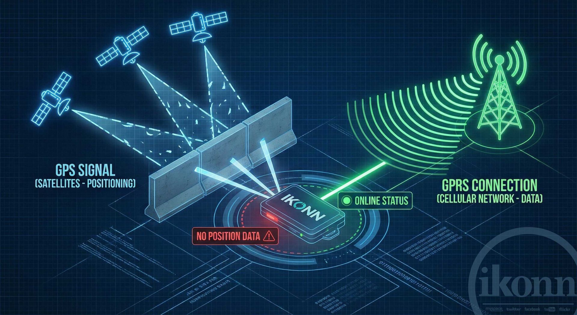
The Paradox of Location-Free Connectivity
In the monitoring world, it's common to find confused operators facing a green "Connected" icon while the map displays an outdated or nonexistent location. To resolve this paradox, it's necessary to dissociate GPRS from GPS . Although they work together within the hardware, they are independent systems that operate on distinct layers of physics and telecommunications. A device may be perfectly capable of "talking" to the server, but completely incapable of "knowing" where it is on the globe.
Modern vehicle tracking is essentially a conversation between space and land, mediated by cellular networks. When one of these channels fails, the equipment's behavior changes drastically. Understanding this dynamic is not just a technical necessity, but a requirement for maintaining logistical efficiency and asset security in operations that demand absolute precision and impeccable data maintenance.
GPRS: The Messenger and the Data Infrastructure
GPRS (General Packet Radio Service) is the layer responsible for communication . It's the technology that uses the cellular network to transport data packets from the tracker to the platform's servers. When a tracker is classified as "online," it means the data tunnel is open and the hardware is maintaining an active network heartbeat. This is the device's voice, the means by which it sends alerts and receives commands from the central monitoring station.
GPRS connectivity depends on proximity to cell towers and the integrity of the M2M chip. A tracker can be online inside a basement or metal warehouse, as long as there is a cell phone signal. However, the presence of a GPRS connection does not guarantee the integrity of the geographic data. GPRS only ensures that, if the hardware has information to send, the path to the server is unobstructed.
GPS: Spatial Precision and Trilateration
GPS (Global Positioning System) is the layer responsible for location . Unlike cellular radio, the GPS module is a passive receiver that listens for signals emitted by satellites in orbit. By calculating the time it takes for the signal to arrive from at least four different sources, the hardware performs the trilateration necessary to determine latitude, longitude, and altitude with metric error margins.
The GPS signal is extremely sensitive. Metal structures, dense concrete, and even certain solar protection films can create a Faraday cage effect, preventing the module from receiving orbital data. This is where the "blind tracker" comes in: it has a battery and network connection (GPRS Online), but it cannot hear the satellites (GPS Offline), resulting in a green connection icon, but no real movement on the map.
Rules Engine: Intelligence in Fault Detection
To elevate the technology beyond the basics, Ikonn utilizes an advanced Rules Engine that automatically identifies this hybrid state. The system not only observes the connection but also analyzes the "age" of the last valid position. If the hardware remains online but stops reporting new coordinates for a specified period, the rules engine triggers a "Frozen Position" or "Invalid GPS" alert.
This layer of logical intelligence allows the control center to proactively identify installation problems, sabotage attempts, or GPS dead zones even before the client notices. Automating these alerts transforms the platform into a preventative diagnostic tool, ensuring that the monitoring infrastructure maintains a consistent and reliable performance standard.
Common Causes and Resolution Protocols
The technical diagnosis must be structured to eliminate variables. If the equipment communicates but does not position itself, the most likely causes include obstructed antennas, vehicles in covered locations, or receiver module failures (Cold Start). The resolution protocol requires taking the vehicle to an area with open sky and monitoring the signal gain (SNR) of the satellites via the platform.
Preventive maintenance and the use of cutting-edge hardware are essential. Equipment that supports multiple constellations (such as GPS, GLONASS, and Galileo) drastically reduces time to fix on position (TTFF), ensuring that the technological duality between talking and locating occurs seamlessly. Mastery of these concepts is what defines an Ikonn-certified tracking operation of excellence.
Conclusion: Integration as a Pillar of Security
Understanding the difference between being online and being positioned is the first step towards the technical maturity of any control center. GPS and GPRS are the two pillars that underpin end-customer trust. By ensuring that both operate in harmony through a robust infrastructure, your company takes full control over the asset protection cycle, delivering a service based on data accuracy and operational efficiency.
IKONN HELP: Elevating technical expertise for high-level results.
Is your operation facing positioning challenges?
Consult our engineering team to optimize your data infrastructure and ensure your control center is making the most of the rules engine for high-precision monitoring.