Shadow Zones and Urban Canyons: Where the GPS signal dies
The metric precision of vehicle tracking faces its greatest challenges in the architecture of cities. Understand the attenuation and reflection phenomena that compromise the integrity of the digital trail.
The Physics of GNSS Fragility
The operation of the Global Navigation Satellite System (GNSS) is based on the reception of extremely weak radio signals emitted by satellites approximately 20,000 km from Earth. For a monitoring center that values the impeccable maintenance of data, understanding that these signals operate at a low-power frequency is the first step in diagnosing faults. When a vehicle enters what we call Shadow Zones , the direct line of sight to the satellites is interrupted, resulting in the momentary or total loss of positioning capability.
These interruptions are not hardware failures, but limitations of microwave physics. Keeping systems in a "brand new" state requires the platform to be able to interpret these information gaps. At Ikonn, we focus on automating the identification of these anomalies, ensuring that technical support acts with surgical precision instead of operational guesswork.
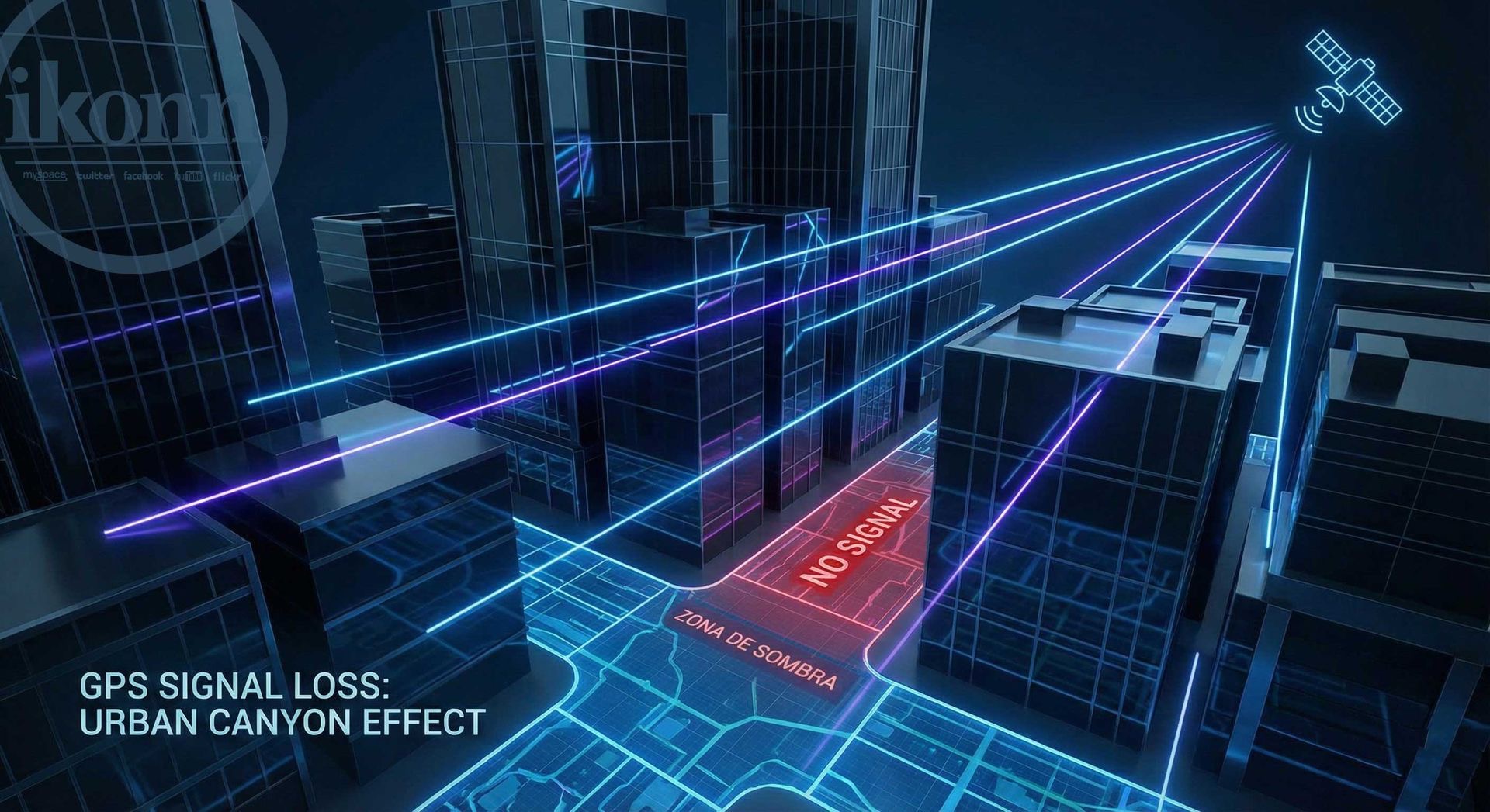
Urban Canyons and the Multipath Phenomenon
The term "Urban Canyon" refers to the environment created by large metropolises, where skyscrapers line narrow streets, simulating geological canyons. For GPS, this scenario is hostile: the signal, instead of reaching the tracker's antenna directly, reflects off the glass and steel facades of the buildings. This phenomenon, known as Multipath , causes severe calculation errors, as the receiver processes the reflected signal as if it were the direct signal, generating "jumps" in position on the map.
In high-performance operations, these deviations can trigger false speeding or geofence violation alerts. Ikonn's Rules Engine is designed to mitigate these effects through filtering algorithms that validate the kinematic consistency of the movement. Automation identifies common error patterns in urban canyons, reducing operational noise and increasing the perceived value of the service delivered to the end customer.
Shaded Zones: Tunnels, Garages, and Dense Vegetation
Shadow Zones are areas where physical blockage is absolute. Road tunnels, underground garages with multiple concrete slabs, and even densely canopied rainforests act as shields against satellite signals. In these environments, the tracker enters a constant search mode, which can increase power consumption if the firmware is not optimized for deep sleep management.
The technical solution for these areas involves the use of complementary technologies. The use of LBS (Location Based Services) allows the equipment to estimate its position through triangulation of cell towers (BTSs), maintaining approximate visibility while the GPS signal dies. For critical operations, integration with Dead Reckoning sensors (Odometry and Inertial) allows the system to "guess" the path within the tunnel based on the last known speed and direction.
Engineering Strategies for Maximum Visibility
To combat geographical limitations, Ikonn encourages the adoption of multi-constellation hardware. Equipment that simultaneously listens to GPS (USA), GLONASS (Russia), Galileo (Europe), and BeiDou (China) has a much higher probability of keeping at least four satellites "in view," even in gaps of sky visible between buildings.
Furthermore, maintaining an up-to-date knowledge base, such as Ikonn University , allows installers to position antennas in a way that maximizes signal gain. The pursuit of perfection in installation is what ensures that, even in challenging environments, the digital footprint remains as faithful as possible to the physical reality of the vehicle.
Conclusion: Resilience in Hostile Environments
Blind spots and urban canyons are unavoidable realities in vehicle tracking. However, how a control center handles these limitations is what defines its market leadership. Through a combination of advanced hardware, intelligent automation via a rules engine, and a robust data infrastructure, it's possible to transform a physical challenge into a competitive advantage of stability and reliability.
IKONN SUPPORT: Precision engineering to overcome the city's barriers.
Is your control center prepared for the challenges of urban geography?
Consult our support and engineering team to optimize your fleet against multipath and dead zones. Ensure maximum data fidelity with Ikonn technology.