What is LBS and how can it save your tracking?
When the sky closes in on GPS, cell towers take over. Understand how Location Based Service ensures your fleet's visibility in critical environments.
LBS: The Geographic "Plan B" of Telemetry
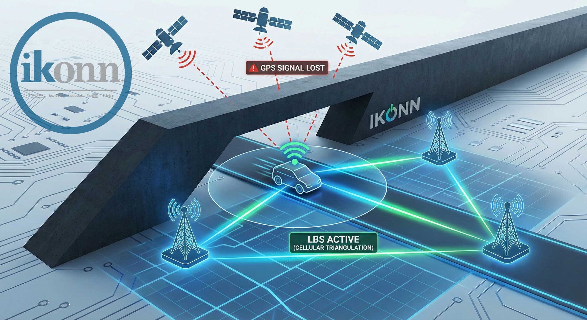
LBS (Location Based Service) is a positioning technology that uses the infrastructure of cellular networks to estimate the location of a device. Unlike GPS, which relies on satellite signals with a direct line of sight, LBS uses the proximity of the hardware to the operator's base transceiver stations (BTS) . For a high-performance monitoring center, LBS is not a substitute for the metric precision of GPS, but rather an operational life insurance policy for situations where sky visibility is nonexistent.
In theft scenarios, where vehicles are hidden in metal warehouses or basements, GPS will invariably fail. This is where LBS shines. It allows the control center to know, at least, in which neighborhood or region the asset is located, providing a critical starting point for rapid response and investigation teams. At Ikonn, we encourage maintaining systems in like-new condition, where every piece of data—even approximate data—is handled with technical rigor.
The Physics of Cellular Tower Triangulation
The LBS system works based on parameters known as MCC (Mobile Country Code) , MNC (Mobile Network Code) , LAC (Location Area Code) , and Cell ID . By collecting this information from nearby cell towers, the tracker sends these identifiers to the platform. The system then cross-references these codes with global databases of antenna locations to project the position on the map.
The higher the density of antennas in the region—such as in large urban centers—the greater the accuracy of the LBS, potentially reaching a radius of 50 to 200 meters. In rural areas, this margin of error increases, but the continuity of the tracking remains. Understanding this variation in accuracy is fundamental to avoid hasty conclusions and ensure that Ikonn's Rules Engine operates intelligently, differentiating a satellite position from a cellular network-based position.
Direct Audit: Verification via the Operator Portal
One of the major strategic differentiators in field diagnostics is the ability to perform external audits. Generally, it's possible to verify the LBS position directly through the M2M connectivity provider's portal . This tool is the "final court" for validating whether the hardware is communicating correctly with the network, even if there is some delay in the platform's processing.
By accessing the SIM card provider's portal, the manager can check in real time which Cell ID the device is associated with. If the location reported by the operator matches the last estimated location by the system, we confirm that the network infrastructure is healthy. This practice drastically reduces support time and gives your call center unquestionable technical autonomy, allowing you to identify whether a "no location" problem is caused by physical obstruction (GPS) or a registration error.
LBS and Automation: Intelligence against "Blindness"
Integrating LBS with Ikonn technology allows the control center to create automatic alert protocols. Through our rules engine, you can configure a specific notification for whenever the vehicle transitions from GPS to LBS in high-risk areas. This alerts the operator that the asset may be entering a deliberate or accidental shadow environment, allowing for an immediate reaction.
Furthermore, the LBS history serves as a trail of breadcrumbs. If a signal blocker (jumper) is activated, it usually focuses on the 1575.42 MHz frequency (GPS), but it can leave the cellular network functional for a few moments longer. Capturing the last valid Cell ID before the total loss of communication is often the detail that guarantees the recovery of a high-value asset.
Conclusion: Resilience as the Ikonn Standard
LBS is not a second-rate technology; it's an indispensable layer of resilience for those governing serious monitoring operations. By mastering the technical distinction between satellite and network location, and by using auditing tools like carrier portals, your company raises the bar for support and delivers much more robust security. At Ikonn, we work to ensure you have complete visibility, regardless of the physical obstacles between the tracker and the sky.
IKONN SUPPORT: Data engineering ensuring the continuity of your trail.
Is your fleet protected by multiple layers of location tracking?
Consult our engineering team to validate your LBS settings and ensure your control panel has full visibility, even in GPS shadow areas.